Last version: 3.0.2020.520
————————————————–
May 20, 2020
In this version, equation of SPT correlations are included in the program. Improvements made in the print preview page.
————————————————–
May 3, 2020
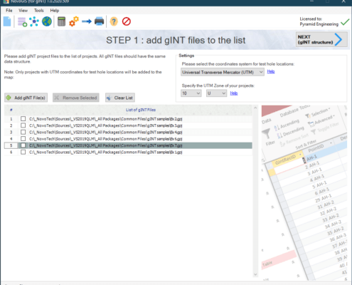
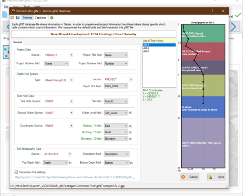
Improvements for import from gINT files (SmartSync) to allow import from more complicated gINT files.
————————————————–
December 8, 2019
Five new shear wave velocity (Vs) correlations were added from PEER 2012/08.
These correlations are developed by Wair and DeJong.
————————————————–
March 6, 2019
Added new flexible licensing system. Minor bug removal and performance improvements.
————————————————–
March 12, 2017
Minor bug removal
————————————————–
February 2, 2014
10 new SPT correlations for Gmax added
————————————————–
February 14, 2013
10 new SPT correlations added (mainly for Es and PMT)
————————————————–
January 29, 2013
A bug removed from the legend of soil profile on correlation page
————————————————–
December 24, 2012
Three new correlations for Su and one new correlation for shear wave velocity are added.
————————————————–
September 20, 2012
Subscription reminder added to the program.
————————————————–
August 2, 2012
– 5 more correlations added for shear wave velocity (from Naresh Bellana)
– a bug is fixed with water level correction on SPT blow counts
————————————————–
July 5, 2012
Chinese (Simplified) and Turkish languages are added to user interface and help file
————————————————–
February 19, 2012
Depth correlation settings is now saved in the project file
————————————————–
January 31, 2012
Depth correction factor (Cn) is now calculated and plotted as user enters SPT blow counts
————————————————–
November 24, 2011
“Getting Started” page added to Help file
————————————————–
September 17, 2011
A bug fixed with depth correlation report where the depth is not correctly shown
————————————————–
August 31, 2011
N1(60) curve is now plotted with N60 and N
————————————————–
August 12, 2011
4 more correlations added for shear wave velocity (Vs)
————————————————–
July 8, 2011
A bug fixed related to calculating effective stress in Imperial units.
————————————————–
May 31, 2011
Now, each layer has its own OCR and D50. This will lead to more accurate results when dealing with those correlations which use OCR and D50.
————————————————–
April 8, 2011
Help file updated.
————————————————–
October 14, 2010
NovoSPT reports can be exported directly to PDF files:
– no need to installation of PDF writer on user’s computer
– lighter PDF files with this new feature
– fast PDF rendering with much higher quality of charts and images
————————————————–
July 10, 2010
8 correlations for CBR based on SPT, added to NovoSPT
————————————————–
July 2 2010
Version 2.1 released. In this version, user can filter correlations based on each layer’s soil type. For example if at 2.3m, soil type is silt and all correlations for Vs are to be shown, user can select to show only Vs correlations valid for silt soils (read article by Alireza Afkhami).
————————————————–
June 25, 2010
2 new correlations from US Army Corp (for modulus of elasticity Es) added to NovoSPT.
————————————————–
June 4 2010
Method of overburden correction factor (Cn) which is applied to N60 to obtain N1(60) for correlations, now can be chosen by user (among 9 methods)
————————————————–
May 3, 2010
5 new correlations for Cone Penetration Test qc from N60 added to NovoSPT
————————————————–
April 24 2010
New module for Dynamic Cone Penetration (DCP) added to NovoSPT
————————————————–
April 12, 2010
new skin feature added to all Novo Tech software applications, making our software more intuitive …
————————————————–
April 5, 2010
– In input data, a description column for each layer is added
– Two columns added to SPT table, for depth correction factor (Cn) and other corrections (Cr.Cs.Cb.Ce) factor
– A new chart added for variation of above mentioned correction factors with depth (see screenshots)
————————————————–
March 12, 2010
two new correlations for Su and dilation angle
————————————————–
March 10, 2010
8 more correlations for pressure meter test!
————————————————–
February 9, 2010
Removed a bug in import from gINT tool.
————————————————–
January 20, 2010
11 more correlations for Vs!
————————————————–
January 19, 2010
Ten new correlations for Go, Vs and Su have been added.
————————————————–
January 11, 2010
User manual (Help) is updated.
————————————————–
January 8, 2010
One more Gmax correlations and 2 more Vs correlations (Alfaro Castillo, 2007) are added.
————————————————–
January 4, 2010
Automatic update tool is added to Novo Tech software products.
————————————————–
December 28, 2009
More references added.
————————————————–
December 25, 2009
Minor improvements in user interface.
————————————————–
December 14, 2009
Version 1.9 just released with Bearing Capacity Analysis tool.
————————————————–
December 13, 2009
The following features are added (both can be found under File menu):
– Save As …
– Open Recent Files
————————————————–
November 27, 2009
calculation of rod length correction Cr is now done automatically.
————————————————–
November 22, 2009
NovoSPT help file updated; please download here.
————————————————–
November 13, 2009
4 more correlations for Su, Es and G0 added
————————————————–
November 10, 2009
5 new correlations of SPT to Gmax and pile bearing capacity added to NovoSPT.
————————————————–
November 9, 2009
Import from Rockware’s LogPlot is added to our products (click here for more information)
————————————————–
November 7, 2009
A new correlation of SPT blow counts to friction angle based on Duncan 2004 is added to NovoSPT.
————————————————–
November 5, 2009
Import from GAEA’s Winlog is added to our products (click here for more information)
————————————————–
October 21, 2009
Import from Microsoft Excel files is added to NovoSPT. Data unit system conversion is also included.
————————————————–
October 16, 2009
A new correlation added for Gmax based on Randolph, 1981
————————————————–
October 11, 2009
Import from Microsoft Excel files is added to NovoSPT. Data unit system conversion is also included.
————————————————–
October 4, 2009
A full documentation has been prepared for “gINT Import Tool” and Help file is attached to latest version of NovoSPT. Please read the online documentation here.
————————————————–
October 2, 2009
Import from gINT feature is enhanced. Automatic soil layers import and unit system conversion is included.
————————————————–
September 26, 2009
A new method of correlation between Vs and N1(60) from Anbazhagan & Sitharam added to NovoSPT.
————————————————–
September 25, 2009
NovoSPT now supports both Imperial and Metric units systems (Upgrade to v 1.8)
————————————————–
September 10, 2009
A new tools added to NovoSPT : Wildcat Dynamic Penetrometer Analysis (the equipment from Triggs Technologies, US)
————————————————–
September 9, 2009
3 new correlation to Dr (Cubrinovski & Ishihara) added to NovoSPT.
————————————————–
September 3, 2009
Two new correlations with Gmax added to NovoSPT.
————————————————–
August 27, 2009
A new feature added to NovoSPT to enable the user for selecting among correlation methods for each parameter. Therefore, scattered plot of the correlated value is now based on user’s selection. For example this feature helps you activating correlations which are applicable to a specific type of soil.
————————————————–
August 25, 2009
Fixed a bug when importing SPT data from gINT database with free format. Also for each correlation in the result tables, reference book/paper and N60/N1(60) is specified.
————————————————–
August 20, 2009
21 new correlation for shear wave velocity from 16 geo-scientists is added to NovoSPT.
————————————————–
August 17, 2009
Save and Load features are added to NovoSPT. Now you can save your calculations into *.spt files and reload them later when you need them. Also the following methods are added to correlations : Wolff 1989 and Kulhawy and Mayne 1990 for friction angle, AND Hara et al. 1974 for undrained shear strength of clays.
————————————————–
August 15, 2009
A preferences feature is added to NovoSPT. The main reason of this page is to set the valid range of correlated geotechnical parameters, since based on some formulae the resulted values are sometimes out of meaningful range (such as F>45º).
————————————————–
August 11, 2009
Cross Correlation is now available in NovoSPT. Using this feature you can plot and compare different methods of correlation for a soil parameter in depth of test hole.
————————————————–
August 8, 2009
Two more correlations of SPT to pile baring capacity added to NovoSPT.
————————————————–
August 6, 2009
Correlation of SPT with Wildcat dynamic penetrometer cone resistance (qd) and correlation with pile end bearing (Reese and O’Neill method) are added to NovoSPT.
————————————————–
August 4, 2009
New feature added to NovoSPT for importing from gINT files compliant with AGS format as well as FREE FORMAT (user can choose mapping tables and fields from database).
————————————————–
July 27, 2009
Import from gINT database files is now available. You may load your existing gINT projects from NovoSPT and select the borehole from auto-populated list to import its SPT/DCPT data for further correlation.
————————————————–
July 25, 2009
NovoSPT reports are now more descriptive; Correlated values for each parameter are plotted in a graph and inserted below corresponding table in the report. See a sample report here.
————————————————–
July 22, 2009
Correlation of SPT with approximate unit weights for Sands and Clays added to the software.
————————————————–
July 21, 2009
Pressuremeter modulus (EPMT) correlation with SPT blow counts added to the software. Also five new correlations for soil friction angle (including Pech, Hanson and Thornburn) are added.
————————————————–
July 15, 2009
Becker Hammer correlations with SPT blow counts added to the software. For more information click here.
————————————————–
July 8, 2009
User manual (Help) is prepared for the program. Download help file here or see online documentation here.
————————————————–
July 6, 2009
First official release.


