Boreholes Manager
On this page you can manage the list of boreholes and edit their properties. The main parts of this page are described below:
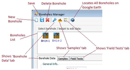
Toolbar
This toolbar is used to insert / save /delete boreholes. The toolbar also provides quick access to the main sections of the borehole data such as "Borehole Data", "Samples" and "Field Tests". If the borehole is actually a test pit, the drilling method "Test Pit" should be selected (see all drilling methods). Please note the deleted data cannot be restored.
Borehole List Panel
This list is located below the toolbar, and lists all boreholes and test pits (with different icons). Click on any boreholes to view and edit its information.
Borehole Data tab
Using this tab you can specify name, method of drilling, total depth, groundwater level, fill thickness, coordinates, etc. Please note:
- Name of borehole should be unique in the current project
- Depth of a sample may not be greater than the total depth of borehole
- Depth of a test field may not be greater than the total depth of the borehole
Samples tab
This section is used for entering a list of samples for selected borehole by specifying their depth, type, color, sample number (Code or ID), and a visual description. If the gradation tests is previously conducted on this sample, the last column will show the USCS soil classification.
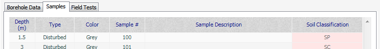
For various sample types please see this article.
Field Tests tab
In this section, the results of standard penetration tests, or CPT, etc. can be entered.
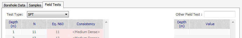
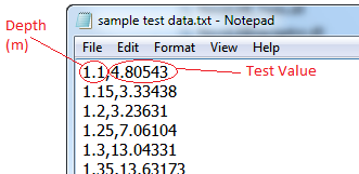
The other field tests could consist of CPT, Vane shear, Down-hole / Cross-hole shear wave velocity and similar tests. For ease of data entry, you can also import the test result from a Text file. To do this, click on the table, then select "From Text File" menu from the main toolbar.
The following described the format of the text file to be prepared for importing field test data.
Locating Boreholes on Google Earth
To use this feature, you need the UTM coordinates of the boreholes. Click on Google Earth icon, then specify the zone name and number to open Google Earth 3D model (more).