Using SmartSync
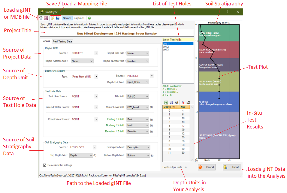
SmartSync user interface allows you specify the structure of your gINT project file. The following figure illustrates various parts of the SmartSync user interface:

⇒ Before you proceed using SmartSync, please learn about Database files.
The first two buttons on the toolbar can be used to load a gINT (*.gpj) or Microsoft Access (*.mdb) files. When you select the source file, SmartSync automatically lists all the tables and corresponding fields.
Next step is to specify where to expect each parameter in the loaded database file; for example gINT typically saves borehole data in POINTS table. Once you specify the database structure, SmartSync saves your settings in a Mapping file, so that the same settings will be automatically loaded for you next time you run SmartSync.
Project Data
Usually gINT project data is stored in PROJECT table. You can specify the fields holding your project's Title, Address and Number.
Depth Units
Please specify the depth units for your gINT file. SmartSync will convert all depths from this gINT depth unit, to the depth unit selected in the software. For example if you use NovoSPT and read your SPT data from a gINT file with depths in feet, and NovoSPT units system is set to Metric, during the import all depths will be automatically converted from feet to metres.
Test Hole Data
Usually borehole data is stored in POINT table, and borehole title (name) is stored in POINTID field. You also need to specify the table and field holding water level data. When more than one water levels are stored in gINT file (e.g. piezometer reading), choose the one which should be used in software.
Soil Stratigraphy Data
Subsurface soil layers are usually stored in LITHOLOGY (or GEOL) table in gINT files. Two key fields "top depth" and "bottom depth" are required by the program to calculate the thickness of each soil layer. SmartSync uses this stratigraphy data to draw a schematic soil profile on the right hand side of the page to help visualizing the selected borehole.
Field Testing Data
This page is used to specify the tables and fields holding in-situ test data such as SPT, CPT, etc (to see how SPT data is handled please click here). When all settings are done, press "Refresh SPT Data!" link to refresh the table. You can use the toolbar on top of the SPT table to save the dataset into Excel, Text and Graphic formats, or to directly print it.
Importing Data
When all the above sections are set, click on "Import" button. In-situ tests and stratigraphy data associated with the selected borehole will be transferred from the gINT database to the program.